The Shroud of Turin · Chapter 11 of 21
The quarry outside the walls: Golgotha and its landscape
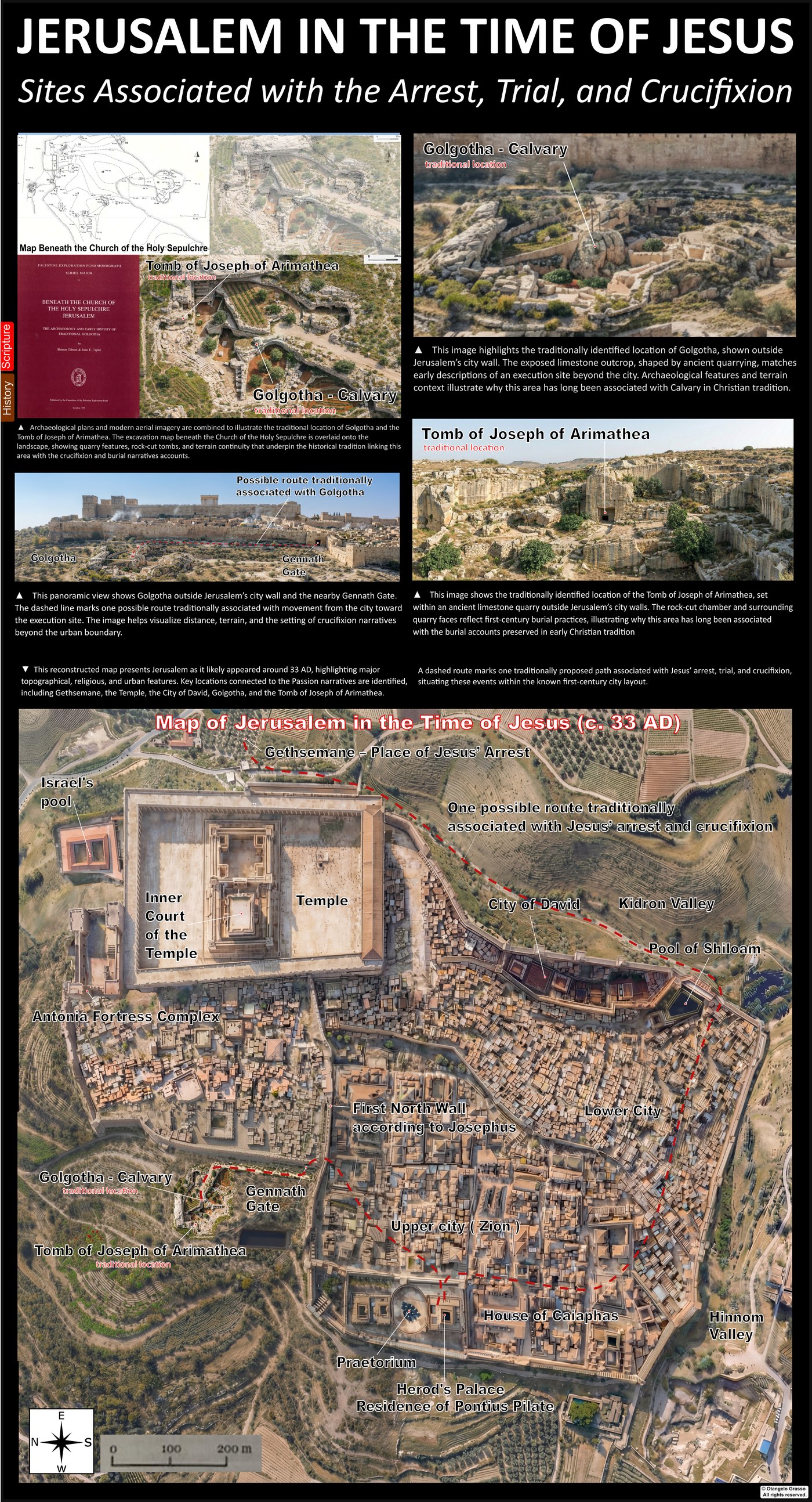
The Gospels say that Jesus was crucified outside Jerusalem, at a place called Golgotha, which means the place of the skull. The place has been identified for almost seventeen centuries with the site now enclosed by the Church of the Holy Sepulchre. The identification rests on tradition, on excavation under the church, and on the ground itself. This chapter looks at each in turn, because the Shroud is said to have been wrapped at a tomb near that place, and the setting bears on the cloth’s story.
What the Gospels say about the place
The Gospels agree that the execution took place outside the city. John says that the place was “near the city” and that Jesus was crucified “outside the gate” (John 19:20). The letter to the Hebrews says he suffered “outside the city gate” (Hebrews 13:12).1 Mark, Matthew, and Luke give the name Golgotha or the Aramaic equivalent, and they note passers-by who mocked him (Mark 15:22, 29; Matthew 27:33, 39).
Roman executions were usually held outside the city and near a road, so that the public could see them. The Jewish law of the Torah also required executions outside the camp (Leviticus 24:14). Those two requirements point to a site outside the city wall, close to a road but not inside the built-up area.2
The city walls in the first century
The line of the city walls in the time of Jesus is discussed in the archaeological literature. Kathleen Kenyon’s excavations in the Muristan area in the 1960s are often cited for the position of the second wall, which placed the area near the Holy Sepulchre outside the city in the first century.3 The third wall, built later by Herod Agrippa, enclosed the area within the city. Scholars disagree about the exact line, so the placement of the site relative to the wall should be read as a broad position, not a precise measurement.
The quarry under the church
The ground beneath the Church of the Holy Sepulchre contains rock-cut features. In 1961 Father Virgilio Corbo, a Franciscan archaeologist, exposed vertical bedrock faces with chisel marks, which he took to be the remains of a quarry.4 The rock is a fine limestone, which was used for building in the region and was quarried extensively in the Iron Age and later. The quarrying created a stepped landscape of cut faces and benches, and some of the rock outcrops were left standing when the stone around them was removed.
The archaeological survey by Shimon Gibson and Joan Taylor, published in 1994, set out measured levels for the principal features: the summit of the rock traditionally identified as Golgotha, an intermediate terrace or tomb bench, and the lower quarry floor. The published figures give the summit about five metres above the tomb bench, and the bench about nine or ten metres above the quarry floor.5 The levels are measured in relation to sea level, and the differences between them are the most useful part of the survey for the question of the setting.
The quarry does not by itself prove the identification. Quarries were common around Jerusalem, and a quarried outcrop could have been used for executions in the first century. The argument rests on the combination of the quarry, the level of the summit, the position outside the wall, and the tomb tradition.
The garden and the tomb
John says that the tomb where Jesus was laid was “in a garden,” near the place of crucifixion (John 19:41–42). Matthew says the tomb was new and belonged to Joseph of Arimathea (Matthew 27:60). The tomb traditionally identified with Joseph is cut into the quarry face at the level of the tomb bench, and it is a rock-cut chamber of a type that is found in the first-century Jerusalem tombs.5
Soil studies under the church have been reported in the recent literature, including botanical remains from early Roman contexts. Those results have been presented as evidence of cultivation in the quarry hollow in the first century. They should be read as reported findings until they are confirmed in the peer-reviewed literature.6
The tomb’s date matters. Rock-cut tombs of the kind found at the site fit the late Second Temple period, roughly 50 BCE to AD 70. A tomb of that type would fit the Gospel description of a new tomb, but the fit does not prove that this particular tomb was Joseph’s.
The Garden Tomb and the alternatives
The most widely known alternative is the site north of the Damascus Gate, called Gordon’s Calvary and the Garden Tomb after General Charles Gordon, who proposed it in 1883. Its appeal is largely visual and devotional. The rock outcrop resembles a skull, and the garden is quiet.
Archaeological assessments of the Garden Tomb have been unfavourable. Gabriel Barkay, an Israeli archaeologist who specialises in Iron Age burial practices, argued in 1986 that the tomb’s architecture is earlier than the first century, and that it cannot be the new tomb of the Gospel account.7 That assessment has been disputed by others, and the Garden Tomb’s dating is not uncontested. The balance of archaeological argument, however, favours the site under the church over the Garden Tomb for the first-century burial.
The road and the crowd
A road ran from the city gate past the quarry area, and the Gospel accounts of passers-by fit that setting. The traffic at the gate would have been large, especially during the festival, and an execution placed next to a road would be seen by many people. Mark and Matthew describe passers-by who mocked Jesus (Mark 15:29; Matthew 27:39).1 This fits the Roman practice of execution in public view, though it does not prove that the road was the one identified in the survey.
What the landscape can and cannot show
The landscape can show that a quarried outcrop outside the city wall, close to a road and to rock-cut tombs of the first-century type, is consistent with the Gospel setting. It can show that the site under the church is a plausible location for a first-century execution and burial. The measured levels show a sensible relationship between the outcrop and the tomb.
It cannot prove that the cross stood on this summit, that the tomb was Joseph’s, or that the sites are the ones named in the Gospels. Those identifications rest on tradition, on the continuity of the site, and on the fit between the evidence and the texts. The next chapters move from the place of execution to the body, and the cloth.
References
- John 19:20; Hebrews 13:12; Mark 15:22, 29; Matthew 27:33, 39. John 19:20; Hebrews 13:12.
- Leviticus 24:14; Roman practice of public execution, as discussed in the historical literature on crucifixion. Publication details to be confirmed before publication.
- Kenyon, K. M. (1967). Jerusalem: Excavating 3000 Years of History. London: Thames and Hudson. Excavations in the Muristan area, as summarised in the archaeological literature. Publication details to be confirmed.
- Corbo, V. C. (1981–1982). Il Santo Sepolcro di Gerusalemme. Jerusalem: Franciscan Printing Press. Excavations beneath the Church of the Holy Sepulchre. Publication details to be confirmed.
- Gibson, S., & Taylor, J. E. (1994). Beneath the Church of the Holy Sepulchre, Jerusalem: The Archaeology and Early History of Traditional Golgotha. London: Palestine Exploration Fund.
- Soil and botanical studies from early Roman contexts beneath the basilica, as reported in the recent literature. Primary publication details to be confirmed before publication.
- Barkay, G. (1986). The Garden Tomb: Was Jesus buried here? Biblical Archaeology Review, 12(2), 40–53.